
STEP Matters 227
- Default
- Title
- Date
- Random
- We recently published an article in STEP Matters about the sorry tale of construction of the new synthetic playing field…Read More
- Back in December 2022 the Sydney North Planning Panel rejected a DA by the owner of Eden Gardens (the Ainsworth…Read More
- STEP representatives and many others with an interest in the well-being of the Lane Cove Valley attended a workshop on…Read More
- One initiative that relates to the Durumbura project was the cultural burn near Browns Waterhole that took place in April…Read More
- The EPA has released a discussion paper on a plan to reduce the use of plastic and the quantity of…Read More
- We recently wrote about the urgency of a decision to cease logging in NSW native forests. Logging cannot continue in…Read More
- I personally got interested in the Francis Barralier story by an indirect route. I found that much of the gravels,…Read More
- Pictured is a first time flowering for our 6-year-old Lord Howe wedding lily, bought originally at Wirreanda Nursery. Huge mystery…Read More
- The quite horrendous series of windy August and September days across SE Australia was felt in Sydney under bright blue…Read More
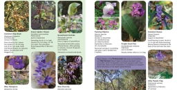
- Friends of Berowra Valley have produced an introductory booklet on the wildflowers commonly met on local ridge tops. It is…Read More
- The STEP Track bushcare site at the end of Kingsford Avenue in South Turramurra meet from 9 to 11 am…Read More


Norman Griffiths Oval synthetic turf debacle continues

We recently published an article in STEP Matters about the sorry tale of construction of the new synthetic playing field at Norman Griffiths Oval in West Pymble. Four months later and nearly a year after the oval was due to be completed by November 2023, the work on the stormwater detention system is still continuing. According to council’s website the completion date is now due to be November 2024.
The original cost estimate was $3.3 million. It is now $5.5 million.
Initial pollution incidents
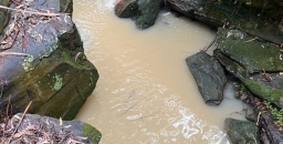
In April 2024 there was a disruption to the works after heavy rain caused a lake to develop on the site. Bushcarers who have been working along Quarry Creek that leads from the field discovered large quantities of sediment-laden water going down the creek. This has happened numerous times. The process of draining the lake must not impact this creek that leads to Lane Cove National Park.
After this flooding was reported to the Environment Protection Authority (EPA) the EPA made several inspections. They noted three pollution incidents:
- 6 to 8 April – the north-east wall of the sediment basin had collapsed and damaged a pipe which resulted in an uncontrolled discharge of sediment laden water into Quarry Creek
- 13 to 15 April – discharge of sediment-laden water from a stormwater outlet on the oval site into Quarry Creek
- around 19 April – as a result of sediment-laden water being leaked, spilled, otherwise escaped or deposited from the oval into water of Quarry Creek, signs of impact were observed in waters of Quarry Creek including the presence of algae and suspended solids for over 200 metres
Council subsequently advised the EPA that the damaged pipe was plugged and a faulty joint in a stormwater pipe had been identified and repaired where sediment laden water had been seeping into Quarry Creek.
Nevertheless, the evidence of pollution led the EPA to issue a clean-up notice on 26 April to repair pollution as defined under the Protection of the Environment Operations Act 1997.
The clean-up notice required council:
- to repair the collapsed sediment dam wall, repair the damaged section of pipe leading from the dam to the stormwater system and reinstate the holding capacity of the sediment dam;
- to assess the condition and operational status of all stormwater pipes running underneath or above at the premises to prevent any further sediment-laden water from entering the stormwater system from the premises;
- to arrange for the sediment-laden water at the premises to be lawfully disposed of and/or discharged in an appropriate fashion that does not result in further environmental harm;
- to remove the build-up of any sediment originating from the premises in Quarry Creek as well as algae and suspended solids in waters of Quarry Creek for at least but not limited to 200 m from the stormwater outlet.
Council was also required to engage an independent and suitably qualified person to review all sediment and erosion controls and identify any existing controls which are in a poor condition or ineffective. This entailed a detailed ‘Sediment and Erosion Control Plan’ for the site. Also, Council was required to engage a consultant to conduct a comprehensive inspection and assessment of the drainage systems beneath the Oval.
The project has been delayed because of the need to construct an extra retaining wall at the north-eastern corner, pump out the accumulated muddy water into trucks and repair the damaged pipes.
But the pollution has continued
Despite all these actions, in June and August there have been more incidents of sediment flowing down Quarry Creek. Some of these incidents have coincided with a rainfall event, but not all.
There is still a significant build-up of sediment along the creek even as far as Lane Cove National Park below Yanko Road. A relatively clean creek with clear water flowing over bedrock now has many pockets of sand and gravel sediment. The clean-up action has not been completed.
Council has acknowledged that the overflows at Norman Griffiths have been ongoing, and it has been working closely with contractors to address them. They advised that a significant issue, which was not immediately apparent, involved turbid water releases linked to the underground infrastructure. Action has now been taken to make the site more resilient, and the contractors are fully aware of their water management responsibilities. Council staff have said they will continue to monitor the creek, and operations staff will maintain the temporary sediment control measures until the oval works are complete.
The EPA is still considering all these incidents and may take further action.
Insights from the court case
In Issue 222 of STEP Matters we describe the case taken to the Land and Environment Court by NGANG (Natural Grass at Norman Griffiths, a group of local residents) for a judicial review of the decision to proceed with the project. The evidence presented during the case revealed shortcomings in the review of environmental factors (REF); that is the report that details the project and explains how the risks during construction and operation of the field will be managed. In this case the REF used assessments undertaken by council and the contractor.
The contractor chose to embark upon construction relying on two REF appendices that were for the installation of ‘a synthetic surface’. They were in no way based on the final design of the field as they were completed almost a decade ago – a geotechnical report (Appendix 6) and supplementary contamination investigation report (Appendix 5). Both reports highlighted the need for further investigation of the unconsolidated fill and asbestos risk. In fact, asbestos has been found during construction and buried onsite so that additional costs have been incurred.
The on-site water detention system is a major part of the project. The previous field area has acted as a stormwater detention system and there were pipes under the field taking water from the upper part of Quarry Creek across to the outlet near the swimming pool. The synthetic turf is not absorbent so the surface rainwater and water running onto the field from the surrounding slopes has to be controlled as well as Quarry Creek water from across Lofberg Road. A new system has had to be designed to allow the water to flow slowly through detention tanks and gravel beds under the surface. The large cost of this system was the reason the original plan to put synthetic turf on the oval was rejected back in 2017.
Given the shortcomings of the REF, the issues with the project were foreseeable and should have been carefully investigated before construction began. Further, the REF’s so-called ‘construction environmental management plan’ that is meant to protect the environment from harm, has already failed on more than one occasion and led to impacts on Quarry Creek, an EPA notice, and further delays.
Following the case, council has had to redesign the field and put in further mitigation measures against microplastic movement.
A clearly inadequate REF has already had major implications for ratepayers - not just adding approximately $1 million to the project that ratepayers have borne - but directly causing substantial delays to the project.
The contract stipulates an ‘external, independent review of the proposed design’ should be undertaken. Has this occurred?
Updated flood study still required
The community’s concern is that ratepayers will continue to pay the price for the REF’s inadequacies. This includes serious issues, some of which were highlighted during the court case:
- a lack of flood study modelled on the current design;
- the lack of examination of the impacts of a probable maximum flood as a result of this development as required under 171A of the Planning Act and its possible catastrophic environmental consequences.
There is also an unacceptable fire report which claims synthetic (plastic) fields are flame resistant.
A flood study on the current design is important for two reasons.
- Firstly, because previous comprehensive flood studies of a proposed synthetic field showed damage to Quarry Creek and led to the project being initially rejected in 2017.
- Secondly, control measures are in place for expected rain events, but uncontrolled flooding could lead to tonnes of plastic blades fragments and cork sludge escaping from the field and polluting Quarry Creek. The synthetic turf has plastic blades that are highly buoyant and can break off as the field is played on. Cork will be used as infill to hold up the plastic grass blades to simulate natural grass. While cork is preferable to rubber tyre crumb infill (which is now banned in many countries because of toxic chemical runoff) the stability of cork infill is not proven in heavy rainfall events as has been demonstrated by the cork sludge runoff from ELS Hall field in North Ryde.
It could be that the area is never under threat from a bushfire or fire on the field, but the REF’s bushfire report is not only factually inaccurate but also completely at odds with the Chief Scientist who recommended these fields should not be placed in fire prone (or flood prone) areas. This recommendation occurred before council's decision to go ahead was made.
Questions and actions for the new council
As noted above, we would like the new council to ask questions about why ratepayers are paying for variations for the contractor hitting unconsolidated fill and asbestos given the contractor chose to rely on these completely inadequate studies to tender for the project.
We would like the new council to follow up on ecologist Roger Lembit's report that noted threats to the Sydney Turpentine Ironbark Forest and the orchids (some classified as endangered) around the oval due to changes to hydrology caused by the construction.
Also unknown is the whereabouts of the vulnerable microbats which were mapped at the oval, as well as the Powerful Owl which roosted in the forest above it. There was also no examination on the impact of the multiple high fences around the field given the area is a wildlife corridor.
We remain unconvinced that plastic blades and cork infill will be kept out of Quarry Creek in extreme rainfall conditions, and we will be watching this very closely. The Chief Scientist recommended that pollutant testing be carried out near synthetic fields. Council has now set up a microplastic monitoring process after intensive lobbying from the bushcare group.
The clean-up of the sediment build up needs to be completed. Council also needs to undertake the flood study of Quarry Creek to ensure is not further damaged by erosion and scouring from excess water coming off the synthetic field. Previous council flood studies clearly highlighted the risk of damage to Quarry Creek, where there is a beautifully regenerated bushcare site. We will be asking council to make any flood studies public and outline how Quarry Creek will be monitored and protected. It is not clear whether the Lane Cove Northern catchments flood study that commenced in 2022 has been completed.
It is a great shame that the local community had to raise money to get the council to assess the field adequately – it is the local community that have somewhat abated a complete flood/pollution disaster at that field. Expert witness reports by Dr Daniel Martens (flood expert) and Roger Lembit (ecologist) warning of issues were sent to council staff and councillors and the court case was only initiated when they were completely ignored. Even after the NPWS called for more time to further assess the REF, the majority of councillors rejected a motion by Councillor Kay that a consultation on the REF should be examined further. Some councillors even tried to pass a motion that NGANG should be made to pay council’s costs for the case. Sadly the experts’ concerns have proven to be justified.
Proper consultation is essential for these expensive projects
This project is a prime example of the need for councillors to take notice of expert advice and carry out transparent consultation. This can provide great insights into the impacts, good and bad of a project.
Currently the legislation does not require a council to carry out detailed consultation or an environmental impact assessment (more rigorous than a REF) on a project like Norman Griffiths Oval as it is deemed to be general maintenance. There were numerous submissions to the draft Guidelines on the Use of Synthetic Turf calling for this to be remedied.
Image: Muddy water in Quarry Creek near Yanko Road (30 June 2024)
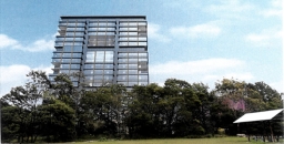
Eden Gardens 18 storey tower development is refused

Back in December 2022 the Sydney North Planning Panel rejected a DA by the owner of Eden Gardens (the Ainsworth family, registered as Thunderbirds Are Go Pty Ltd) on Lane Cove Road, Macquarie Park to build an 18 storey office tower and other facilities. This plan was originally rejected by Ryde Council in March 2021. The applicant made no attempt to address the many issues given for the council’s rejection such as traffic, visual impact and impact on Lane Cove National Park (LCNP) next door. Therefore, the panel’s rejection decision was expected.
The next step was inevitably a Land and Environment Court hearing. This occurred in February 2024. It has taken until September, more than six months later, for the court commissioner to make a final ruling. To everyone’s relief, the application was refused.
The judgement centred on the legal considerations of:
- a merit contention of whether the visual impact was acceptable
- a jurisdictional prerequisite that the traffic impact would satisfy the terms of the Transport and Infrastructure SEPP
Submissions on environmental impacts
Several representatives with an interest in LCNP made presentations to the court hearing such as the NPWS, Friends of Lane Cove National Park, 416 Group, STEP and aboriginal cultural and heritage representatives.
Ryde Council’s submission also made several objections to the impacts on LCNP:
The development creates an unacceptable interface with LCNP, impacting on fauna habitat values, vegetation integrity, aquatic ecological values with the jarring building height resulting in significant visual impacts upon sensitive surrounding areas. These impacts are inconsistent with the zone objectives of C1 National Parks and Nature Reserves within the Ryde LEP 2014.
The judgement made little reference to the environment. Negotiations prior to the hearing did lead to the addition of a condition of consent in relation to light spill. The only other environmental consideration was the impact of shading on an area of endangered Duffys Forest near the development that was discounted because it applied only during a short period of winter. Other issues raised such as risks to birds from reflection of sunlight off the tower, light disturbance to nocturnal animals or bushfire evacuation were not covered in the judgement.
There is going to be increasing pressure for development abutting bushland that will increase bushfire risks and impacts on wildlife. It is concerning that the legal process does not seem to give these issues enough consideration. Legal judgements usually quote extensively from other precedents that relate to past cases. Environmental issues are evolving all the time, especially the impacts of climate change. How can we progress the interest of the natural environment in this backward-looking situation?
The main issue – traffic
The development application (LDA2021/0095) was for alterations and additions to the existing garden centre and construction of an 18 storey office building including car parks with a total of 539 car spaces and additional dining space. All these aspects of the development will obviously generate more car movements. The garden centre is to remain in place.
A lot of the court hearing processes related to options for road access modifications and a proposed pedestrian bridge over Lane Cove Road. Nevertheless, the commissioner commented that the application process was fragmented in relation to this most important issue. She commented:
I observe, merely by way of comment, that none of the parties seem to have properly grappled with the status of the relevant roads adjoining the site until very late in the proceedings including up to and during the hearing.
Basically, the applicant contended that there would be no adverse impact on classified roads, namely Lane Cove Road and the M2 access ramps. When Ryde Council and Transport for NSW raised this issue they made an attempt to respond by proposing to build a pedestrian bridge over Lane Cove Road from near Fontenoy Road to Eden Gardens. The commissioner dismissed this as a ‘red herring’. It was a half-baked idea. Several trees would have to be removed that currently shield the unit blocks on the western side. It would not help commuters walking from the Metro Station as they would still have to cross the M2 link roads somehow. A few residents near Fontenoy Road might have benefitted, that is all.
The applicant suggested some options for easing congestion at the access to the site and intersection with Fontenoy Road. The commissioner considered that the modelling demonstrated that, even with the implementation of mitigation measures such as extra turning lanes, the volume of traffic generated by the development would have clear adverse effects on the safety, efficiency and ongoing operation of the M2 and Lane Cove Road.
Visual impact
The applicant’s experts argued that the tower was desirable because:
A tower form with its small footprint enables activation of the ground plan and uses that continue the functions that the community currently enjoy on the site.
They are also taking advantage of the situation that there is no height limit for the site specified in the Ryde LEP. There is however a maximum floor space ratio 1:1. The proposed development would have a floor space ratio of 0.996:1!
Four aspects of the obvious visibility of the 18 storey tower (80 m high) were considered:
- Consistency with the urban landscape as defined by the objectives of the Ryde LEP. The court decided that was compatible with the appearance of the area even though the tower would be 60% higher than the nearest tall buildings on the southern side of the M2.
- Its proximity to LCNP. The site is next to the Tunks Hill Picnic Area so one would expect an 80 metre high tower would have a big impact. Some experts argued that the picnic area is not totally immersed in the national park. Unfortunately, the LCNP website states that one of the features of the area is its ‘great views of Chatswood’. The fact that these are very distant views with dense forest in the foreground did not have any relevance to the court.
- Its proximity to other parts of LCNP is dismissed on the grounds that it would not be visible from other picnic areas or recognised walking tracks further into the park, where it would be screened by topography. This ignores the topography aspects for all the residents on the northern side of LCNP.
- Visibility to road users. Current views for drivers along Lane Cove Road, de Burghs Bridge and the M2 can enjoy a vista of bushland when travelling near the Eden Gardens site. Town planning experts provided differing views, one that the tower will have an adverse impact, another said the view would only be fleeting for cars on the M2 and there are already numerous views of high development nearby. The commissioner considers the impact to be acceptable. So much for the idea that cumulative impact of adding another high rise interruption to bushland views along the M2 is an intrusion for many people.
On these grounds the arguments about visual impact were deemed to not merit the refusal of the DA.
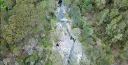
Lane Cove River restoration – the Durumbura Dhurabang stakeholder project

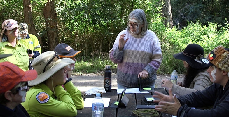
STEP representatives and many others with an interest in the well-being of the Lane Cove Valley attended a workshop on 16 August organised by Macquarie University. It was led by Dr Jo Rey from the Department of Indigenous Studies.
The restoration project is a recent Dhurag initiative aiming to return traditional custodial ontologies, knowledges, languages, practices to the Lane Cove River catchment in respectful alliance with existing stakeholders.
The goal is to bring best practices together for the well-being of Ngurra/country knowing that if we have healthy country we can have healthy people for a sustainable future.
The participants were representatives from local councils, academics, Macquarie Business Park companies, environment groups, indigenous communities, government organisations such as Sydney Water and NPWS.
The workshop was an initial idea sharing exercise to identify knowledge gaps, issues, barriers to improvement and initial priorities for action.
Urban planning impacts on the catchment
The workshop identified one of the major issues for the catchment is the lack of coordinated monitoring of water quality and modelling of stormwater management requirements. This is vital with the increasing incidence of extreme rainfall events and the rapid increase in residential development and associated infrastructure.
A matter of concern is that there are currently no flood-related development control provisions applying under the Ku-ring-gai local environmental plan. A number of catchment flood studies are being undertaken subject to funding from the NSW government but these are progressing very slowly.
Our planning system needs a major upgrade to improve stormwater controls and reduce pollution from run-off and erosion. All governments and organisations like Sydney Water have to be involved.
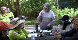
Dharug women's-led cultural burn at Browns Waterhole
One initiative that relates to the Durumbura project was the cultural burn near Browns Waterhole that took place in April 2024. Dharug women and allies worked together to undertake the first (since earliest colonisation days) Dharug women’s-led cultural burn. The information in this story comes from Regenavitis, the newsletter of the Friends of Lane Cove National Park.
The cultural burn originated from an invitation and funding from the Department of Planning and Environment’s Cultural Fire Management Team to the Dharug Yanama Budyari Gumada Collective. Macquarie University was also involved with the management of the burn. It is the first time Dharug women have been invited by a government department to restore Dharug cultural knowledges, language, and practices through fire, as a Caring for Country initiative so close to the inner city.
It was actively supported by a variety of Dharug community members as well as the NPWS, Friends of Lane Cove National Park, the three relevant local councils (Hornsby, Ku-ring-gai and Ryde) and the Rural Fire Service. It took about four years to plan the project including preparing a review of environmental factors and developing the burn plan.
The journey involved Dharug women holding a women’s camp in May, 2023, thanks to Ryde Council permitting Dharug women to camp at Waterloo Park – another first! Over the three days of the camp, Dharug women renewed cultural connection to Ngurra/country, engaged in ceremonial practices, storytelling, yarning, weaving, made place-based art, did some tools-based training with NPWS, and engaged in digital data collection thanks to Macquarie University scientists. In the process, they were able to establish the presence of swamp wallabies, bandicoots, goannas, turtles, gudgeons, diamond pythons, echidnas, a large variety of culturally important plants, and, of course, ever-present multitudes of sulphur-crested cockatoos, bell minors, kookaburras, various finches, parakeets, and other important bird species. Soil testing, before and after the burn has also been undertaken to determine changes in soil quality.
Originally it was supposed to be completed by 2023, but due to COVID and poor weather conditions, the burn was delayed until 2024. As such the undergrowth grew in height from around 1 m in 2021 to nearly 2 m in 2024. Nevertheless, the delay allowed for greater time to plan and budget. In March, 2024, Dharug women and allies came together to prepare the site for the burn and it was completed in April. It will be interesting to observe the impact of the burn on the forest ecology in coming years.
Group’s summary of the experience was:
While Dharug women have undertaken the cultural burn according to our cultural priorities of nurturing Ngurra (her soils, plants, animals and other presences), we recognise that based on the contemporary context, working collaboratively together with our allies enables us to continue our cultural ways of knowing, being and doing, as well as bringing others along the journey to establish sustainable futures in the city. Undertaking our cool-fire burn approaches mitigates the threat of mega-fires in the Durrumburra Dhurabang (Lane Cove River) valley, and simultaneously restores and strengthens an appreciation of the values that caring for Ngurra/country enacts.
Plastics reduction – have your say on proposed actions

The EPA has released a discussion paper on a plan to reduce the use of plastic and the quantity of waste generated. Comments may be made via a survey or you can email a submission to This email address is being protected from spambots. You need JavaScript enabled to view it. (closing date 6 November).
Due in part to past litter reduction initiatives such as the Return and Earn recycling scheme and the phase-out of lightweight plastic bags, there has already been a 49% reduction in litter density since 2018–19.
What about a major source of plastic – synthetic turf?
As an aside, there is a major source of plastic that is only going to get worse that is from synthetic turf playing fields and its general use for surfaces in parks and school grounds. This issue doesn’t come under the plan but could be referred to in submissions.
There is no effective method for recycling this product. Microplastics that end up in the environment from the break-up of the plastic grass blades and loose infill are a major concern that is being monitored by the AUSMAP project. There will be more about research on this in a future issue of STEP Matters.
Strong action is needed
There are still frightening statistics about the impact of litter and the volume of plastic ending up as waste in landfill. For example, in 2022–23, NSW alone generated 891,000 t of plastic waste. Only 14% of this was recycled.
About 79% of litter washed into our waterways is plastic. Plastic litter can have disastrous consequences and significant cost on the environment and communities.
For every piece of litter on land in NSW, nine times more can be found in our waterways.
As littered plastic items are exposed to water, sunlight and rain, they can break down over time into microplastics and leach potentially harmful chemicals into the environment. It can also entangle or be swallowed by marine animals.
Taking into account the direct costs of cleaning up litter, as well as the indirect costs associated with loss of amenity and environmental values, litter costs NSW more than $500 million.
Is the reduction plan good enough?
The Boomerang Alliance’s view on the proposals is that the plan includes some sound policy actions and a timeline for implementation, but many of these proposed measures may not deliver the needed reductions in plastic litter and waste. Here is a summary of their main points
Reusable cups at food venues (applied from 2027)
Currently, food venues may voluntarily accept reusable cups, but this needs to go further. All outlets should be required to offer reusable cups and containers or accept BYO, reducing reliance on disposables. In Europe, dine-in customers are never served with disposable food ware.
Recyclable single-use cups and containers (2027)
While recyclable or compostable containers are already common, the issue lies with inadequate collection systems. Simply labelling items for recycling won’t address the core issues.
Return and earn for single-use cups and containers (2030)
This proposal is both tokenistic and impractical. What we need is a robust reusable cup return system. Other countries have already implemented these models, which reduce plastic waste and greenhouse gas emissions. These systems could be adopted now.
Tethered caps on bottles (2030)
One never knows whether loose caps from milk and soft drink bottles can be recycled. Attached caps solve this question. This strong policy is already in place in Europe. So, why wait until 2030? Propose that it be introduced by 2026.
National approach to cigarette butt litter (2027)
Ideally eliminate cigarette filters altogether, as recommended by the World Health Organisation. A reusable holder could replace the need for single-use filters.
Elimination of harmful chemicals in packaging (2027)
While this is a positive step, if chemicals are harmful, they should not be used in the first place. Mandatory labelling of ‘green-listed’ chemicals is also essential.
Phase-out of microplastics (2025)
Support this, but there should be stronger measures, such as mandating filters on washing machines to capture microfibres, rather than relying on a proposed rating system by 2027.
Standards for reusable shopping bags (2025)
Require plastic shopping bags to be stored out of sight at the point of purchase and only provided on request, unless they are clearly designed for reuse or are part of an extended producer responsibility. Reusable bags must be durable, contain recycled content, and be recyclable at the end of their lifecycle.
Phase-out of various plastic items (2027)
Agree with the phase-out of plastic carrier bags, food tags, and other non-compostable items.
Ban on lighter-than-air balloons (2025)
This ban could be implemented immediately. There is no need to wait until 2025.
Phase out of expanded and foamed plastic trays and packaging (2025)
Support this phase-out and believe it should be done as soon as possible.
A final word on the Australian recycling label
This system needs to ensure that labelled items are genuinely recycled, reused, or composted. Without this, it’s simply greenwashing.
Take action for forests

We recently wrote about the urgency of a decision to cease logging in NSW native forests. Logging cannot continue in public native forests without pushing the koala, greater glider, coastal emu and many more forest-dependent wildlife species much further towards extinction. Illegal logging practices, endangered species habitat destruction and totally inadequate pre-logging wildlife surveys have become the norm for Forestry Corporation. Under current rules, the volume of logs taken is considered more important than endangered wildlife.
There is now a great opportunity to act to cease native forest logging in NSW. The NSW government is developing a Forest Industry Assessment Plan that will shape the future of forestry in NSW. Ending native forest logging is one of the options being considered. There is a call for submissions to the Independent Forestry Panel that will assess the sustainability of current and future forestry operations.
This is a historic opportunity to finally win this long fought for campaign. Take action by making a submission by 13 October to the Independent Forestry Panel. Click here for the Nature Conservation Council’s submission guide and further information.
The Frenchman: Francis Barrallier, Life and journeys 1773–1853

I personally got interested in the Francis Barralier story by an indirect route. I found that much of the gravels, like those at Penrith Lakes, that have flooded down across the inner Sydney Basin had been washed from a vast Devonian age volcanic formation called the Barrallier Ignimbrite of the Wollondilly Valley in a district known as Barrallier. So we visited the area via the Wombeyan Caves road and also read a version of his diary of attempts, in 1802, to penetrate and cross the Blue Mountains. All useful background, and an introduction to the challenging terrain, but this new book is currently the best source for information and the whole historic setting.
Barrallier and his party set up a depot at Nattai and made three journeys that could be termed ‘excursions’ or ‘incursions’ depending on one’s point of view. The motives were complex, stimulated by Governor Phillip King’s curiosity, and framed by the knowledge of the times, the confronting physical presence of the Blue Mountains and what lay beyond. But the concept of meeting the ‘King of the Mountains’ was also in the thoughts of the time.
The first journey in November 1802 was investigative and followed the Nattai River down to its confluence with the Wollondilly, which they crossed and made an attempt to climb Tonalli Peak, a fearsome, projecting sandstone cliff flanked by blocks and debris. They failed but shot a rock wallaby for food. They were impressed by its sense of balance and ‘mountain goat’ terrain ability – and this was possibly the first European sighting of this animal.
Barrallier's second journey, November to December 1802, was the big one. His party began by following the earlier route to the lower slopes of Tonalli, then proceeded westwards following the Tonalli River and valley past the locality now known as Yerranderie (which became a silver mining settlement). They climbed through the narrow Byrnes Gap and descended to the Kowmung River, crossing it and following tributaries Christys Creek then Wheengee Whungee Creek. This became an increasingly a tough route, rocky, and with waterfalls and ravines, and I should highlight here that they were not in typical Blue Mountains horizontal sandstone country but folded Devonian Lambie Group basement terrain of folded conglomerate, sandstone and shale – quite a different challenge. And this brought the journey to a halt at Johnston Falls. At 30 metres, this waterfall below Kanangra Walls is substantial and there’s an impressive picture in the book that indicates why it stopped them. And the option of climbing out to the Boyd Plateau was not on the table in dry, December heat. They finally gave up and turned back.
Some people have misunderstood the failure to have been due to breach of Aboriginal tribal territory but this wasn’t the case. Their relationship with the locals was mixed and eventful but had positive elements, including employing essential guides like Gogy and Boodbury. Negative aspects include cases of ‘domestic abuse’ particularly by Gogy of his female partner, and the burning of the Nattai depot huts. Botanist George Caley features in the book too through an incident in which accusations of shooting at Aborigines were aired, though not supported by the accused. Barrallier’s recorded botanic observations aren’t of great consequence.
Note: Andy Macqueen has also written a fascinating book about the history of the Grose Wilderness and the saving of the Blue Gum Forest called Back from the Brink.
Andy Macqueen (self-published) 2024,
paperback, 247 pp, RRP $40
Available from This email address is being protected from spambots. You need JavaScript enabled to view it. or Blue Mountains bookshops.Review by John Martyn
Lord Howe wedding lily – one of botany’s greatest mysteries

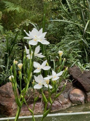 Pictured is a first time flowering for our 6-year-old Lord Howe wedding lily, bought originally at Wirreanda Nursery.
Huge mystery surrounds this species, Dietes robinsoniana, which is incredibly disjunct and all of its near relatives are South and East African – you may have D. grandiflora and/or D. bicolor in your garden and the former is widely used in landscaping (and is also a tough and troublesome weed). But how did a species of the genus jump two oceans with no obvious links and no near relatives?
Lord Howe is the remnant of a 7 million year old Hawaiian-type shield volcano of basaltic composition and it sits on the western edge of Zealandia, a largely-submerged continent and our nearest continental neighbour. That date captures the plant's older time bracket and Lord Howe was never part of much older Gondwanaland wherein the plant might have got there by land.
Nobody seems to have published a solution. The Wikipedia entry is the best and it cites a Dietes paper by Peter Goldblatt of Missouri Botanic Gardens who tries to put D. robinsoniana into context, suggesting a connection via India when the continents were merged but was clearly unaware of the nature and age of Lord Howe. But interestingly he also concluded that D. robinsoniana is the most primitive of the genus and possibly ancestral to the rest – how about that for a brain stretch?
John Martyn
Wild and woolly westerlies

The quite horrendous series of windy August and September days across SE Australia was felt in Sydney under bright blue skies. Further south and in Tasmania however the wind gusted up to category 3 cyclone strength with torrential rain and widespread flooding. We are getting weird and wonderful and often not so wonderful weather outbreaks, usually fires and floods, which are often attributed to or amplified by climate change, but what exactly led to this one?
On 3 September, Caitlin Fitzsimmons, the Sydney Morning Herald’s environment and climate reporter, explained that it’s largely the fault of the jet streams. Two jet streams affect Australia, the subtropical and polar. They both blow fiercely from the west at altitudes of ±10,000 metres but are normally separate at this time of year. However, they have merged across the south of the continent and have amplified each other. The subtropical tends to stay aloft, however the polar often drives weather at lower levels and is linked to the Roaring Forties wind belt of the Southern Ocean within which this dangerous weather resides.
What has climate change done to cause this? Climate change in the Northern Hemisphere has already been blamed for amplified bends and deviations in jet stream paths leading to bottled-up heat domes and devastating fires, or southward surges of the Arctic vortex feeding intense chill across continental Eurasia and North America. Our recent experience is more complex! Warming is apparently nudging the subtropical stream southwards away from the equator while warming and ice melt in Antarctica may be easing the polar one northwards.
John Martyn
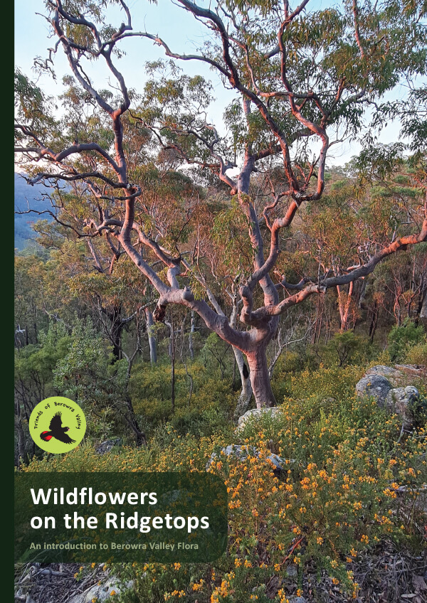
New booklet: Wildflowers on the Ridgetops
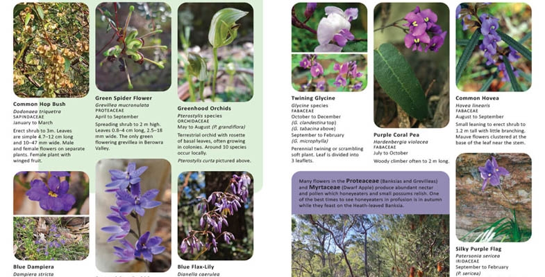
Friends of Berowra Valley have produced an introductory booklet on the wildflowers commonly met on local ridge tops. It is light weight and hence suitable for carrying in a backpack. Flowers have clear photos and are arranged by colour. An amazing Christmas present. Order online – the cost is $10 plus postage.
STEP Track bushcare needs volunteers
The STEP Track bushcare site at the end of Kingsford Avenue in South Turramurra meet from 9 to 11 am on the first Saturday of every month, and they’d love more volunteers.
For more information contact Margaret (0420 511 940) or register with Ku-ring-gai Council online.
A bit of history ... the STEP Track
In 2018 STEP celebrated it's 40th anniversary. To commemorate the event, Graeme Aplin wrote a history STEP Forth Boldly: STEP Inc from birth to 40. Here's what's said about the history of the STEP Track.
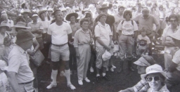
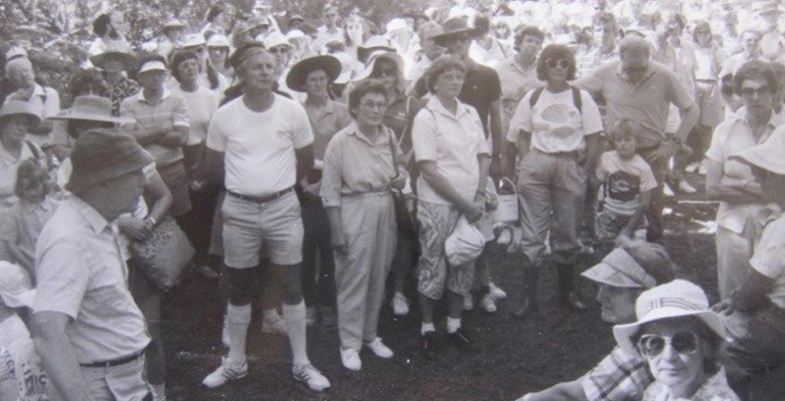
STEP took part in Heritage Week each year, normally by providing a bushwalk. In 1989 this was along the STEP Track, highlighting possible impacts of road proposals: close to 300 walkers attended and the walk was led by Yvonne Langshaw and Alan Catford (Newsletter 38, May 1989).
In an effort to develop a system of high quality walking tracks in the municipality, Ku-ring-gai Council successfully applied for a grant to upgrade what had been known for many years as the STEP Track.
The STEP Track originated when some of the early STEP activists such as Alan and Janet Catford, John and Margaret Booth and Helen Petersen decided that a walking track should be made in South Turramurra which showed more of the diversity of the bushland. On 3 April 1993 over 100 people gathered at the end of Kingsford Avenue to attend the official opening (Newsletter 61, April 1993).
Picture above is the STEP Heritage Week walk and B3 protest (16 April 1989)